The Battle for Bab al-Mandab: Houthis Seek to Consolidate Coastal Gains as Government Forces Hold the Heights
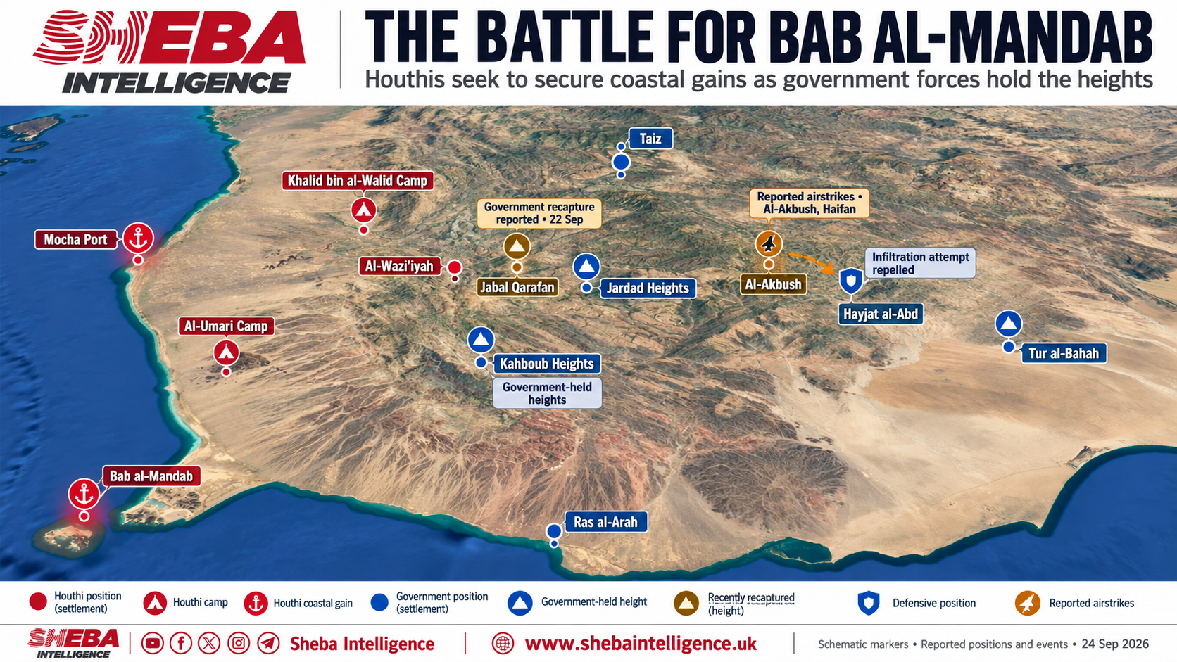
An attempted Houthi infiltration near the Hayjat al-Abd road, a vital connection between Taiz and Yemen’s interim capital, Aden, has renewed concerns over the security of the city’s southern access routes. The incident comes amid fighting across the highlands of southern Taiz, western Lahj and the approaches to Bab al-Mandab.
Yemen’s official Saba news agency reported on September 23 that troops from the Fourth Mountain Infantry Brigade had thwarted an infiltration attempt in the Al-Ashbut and Hayjat al-Abd area of Al-Maqatirah district, Lahj governorate. According to the government account, Houthi fighters were attempting to reach positions near the road and threaten civilian traffic. Government forces secured the area and reopened the route after the threat had passed. The announcement did not indicate that the Houthis had taken control of the road.
Following the infiltration attempt, aircraft struck Houthi positions and concentrations of fighters in Al-Akbush, in Haifan district, according to information provided for this report. The same information identified Al-Akbush as the area from which the infiltrators had advanced. The strikes and their results have not been independently verified.
The road’s importance extends well beyond the immediate battlefield. It carries passengers and goods between Taiz and the south, making any disruption a threat to civilian movement and supply routes. For residents of Taiz, pressure on this connection revives memories of the siege that began in 2015.
The infiltration attempt followed the government’s announcement on September 22 that its forces had regained full control of Jabal Qarafan, in the Haradh Jardad area of Al-Shamayatayn district, southern Taiz. Major General Abdulaziz al-Majidi, chief of staff of the Taiz Military Axis, said troops supported by local fighters from Bani Omar had captured the mountain after battles with Houthi forces. He added that Houthi mortar fire against government positions was continuing.
Qarafan’s significance lies in its position within the Jardad front and the areas connected to Al-Wazi’iyah. Holding the mountain strengthens control over local high ground and surrounding routes. Its relevance to the coastal campaign comes through these connected inland fronts; describing it as directly overlooking the Bab al-Mandab strait would overstate its geographical position.
The Kahboub mountains, by contrast, have a more immediate role in the battle near the strait. Located in Al-Mudaribah and Ras al-Arah district in Lahj, adjacent to Dhubab district in Taiz, the heights provide observation over surrounding roads and approaches. They also form a defensive barrier against an expansion of the coastal fighting farther into Lahj.
Military sources reported on September 17 that government forces had retaken the Kahboub heights. On September 20, the government-aligned Nation Shield Forces announced that they had repelled a Houthi attack on their positions there and shot down a one-way attack drone. Claims concerning the extent of territorial control and battlefield losses remain difficult to verify independently while fighting continues.
These clashes follow the Houthis’ capture of Mocha on September 10 and their subsequent advance into Dhubab and Mayun Island. Those gains shifted the focus of the campaign toward the surrounding highlands and the routes connecting the coast with inland Taiz and Lahj. Consolidating control along the coast now depends in part on the balance of forces on these adjoining land fronts.
The pattern of Houthi attacks suggests an effort to push government forces away from positions that could threaten the group’s coastal deployments. Simultaneous pressure on roads and inland access routes could also force government units to divide their resources between protecting supply lines and defending the high ground.
Al-Wazi’iyah’s mountains, valleys and ravines complicate efforts to maintain continuous defensive lines. The terrain can facilitate infiltration and conceal movement, while also restricting the passage of troops and equipment. Geography alone, however, does not establish how the Houthis are using individual routes or whether vegetation provides decisive cover across every sector.
For government forces, retaining Kahboub and the heights of southern Taiz provides defensive depth for the western approaches to Lahj and the areas connected to the Ras al-Arah coast. It also preserves their ability to maintain pressure toward the coast. Protecting Hayjat al-Abd is part of the broader effort to keep frontline units connected to their supply areas.
Any government attempt to recover coastal territory would depend on developments around Dhubab and Al-Umari to the south, and Mawza, Khalid bin al-Walid camp and the eastern approaches to Mocha farther north. Jabal al-Nar lies east of Mocha, while Khalid bin al-Walid camp, in Mawza district, occupies an important position in the road network connecting Taiz, Mocha and Hodeidah. These geographical relationships do not, by themselves, establish an announced operational plan or a fixed sequence of advances.
The fighting reflects competing efforts to hold territory and shape the next phase of the campaign. The Houthis need to shield their coastal gains from pressure originating in the highlands. Government forces need to retain those heights and protect their supply routes to preserve the possibility of recovering lost ground. Along the contested routes, civilian communities remain exposed to fighting, disrupted travel and further displacement.